meekaalankwiki mihši-maalhsa – mikaalitioni kiihkayonki
The Mihši-maalhsa Wars – Part II – The Battle of Kiihkayonki
This article is the second of a five-part series on the history of our wars with the Mihši-maalhsaki (Americans), which occurred from 1778-1794 and from 1812-1814. This second article focuses on the Battle of Kiihkayonki, also known as Harmar’s Defeat. If you want to hear the pronunciation of the Myaamia terms in this article, please visit our online dictionary at: www.myaamiadictionary.org
In Part I of this series we looked at some of reasons behind the increased violence between Myaamia people and the Mihši-maalhsa (Americans) in the 1780s. When we left off, the Americans were desperately trying to assert the legitimacy of their claims to the Ohio River Valley in the Treaties of Ft. Stanwix (1784), Ft. McIntosh (1785), and Ft. Finney (1786). However, these treaties were largely viewed as fraudulent by Native peoples living along the Kaanseenseepiiwi (Ohio River), Taawaawa Siipiiwi (Maumee River), and Waapaahšiki Siipiiwi (Wabash River).
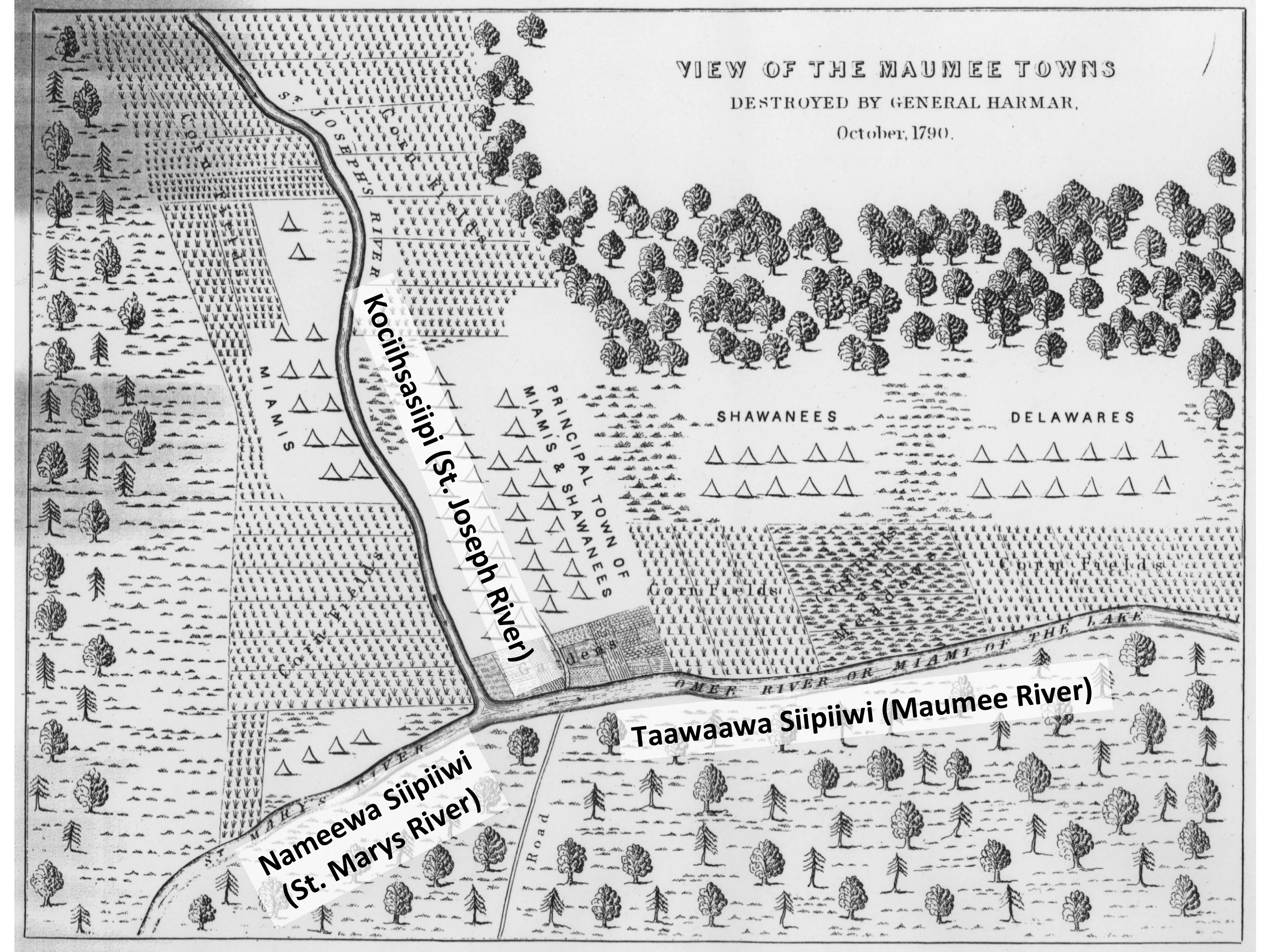
Following the defeat of La Balme (see last article), the Myaamia continued to raid American squatters along the Kaanseenseepiiwi (Ohio River). In response, the Mihši-maalhsa organized many raids on Myaamia, Delaware, and Shawnee villages throughout the region. This war of reprisals and retaliation forced Shawnee and Delaware villages to move ever farther north of the Kaanseenseepiiwi. Eventually, they were invited to build villages along the Taawaawa Siipiiwi, mostly to the west of the two Myaamia villages, which had been located there for generations (see the map below). The Myaamia village on the west bank of the Kociihsasiipi was the oldest and known by the name Kiihkayonki. Its twin across the river was usually called Miamitown or Le Gris Town, after it’s leading chief. However, because of the importance of Kiihkayonki, Myaamia people across time have tended to refer to the whole area around the confluence of the Taawaawa Siipiiwi as Kiihkayonki.[1]
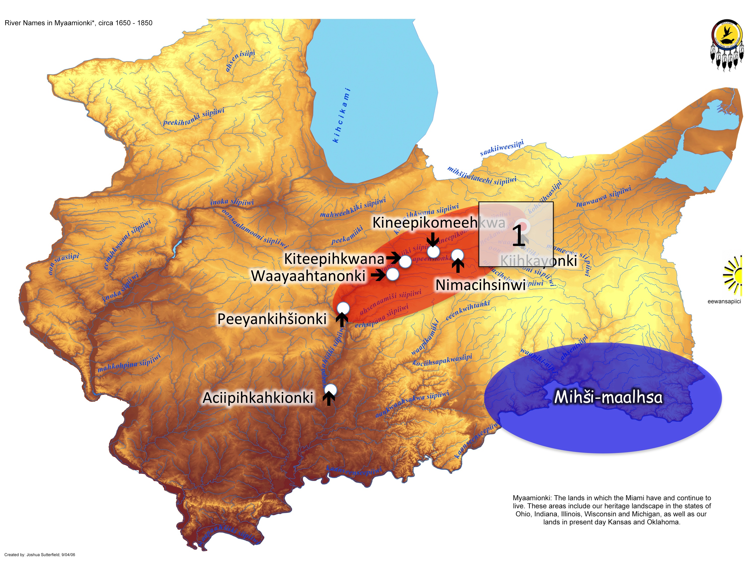
By the late 1780s, a large contingent of Myaamia, Delaware, and Shawnee were living along the Taawaawa Siipiiwi and its feeder streams. For this reason, I’ll be referring to these allied peoples as the Taawaawa Siipiiwi villages (the Maumee River villages). On the last day of the Battle of Kiihkayonki, Potawatomi, Sauk, Meskwaki, and Ottawa men joined in the fight against the Mihši-maalhsa. However, the bulk of the men defending Kiihkayonki throughout the nine days of the battle were from the Myaamia, Shawnee, and Delaware villages on the Taawaawa Siipiiwi.
In this same period of time, the Congress of the United States passed the Northwest Ordinance (July of 1787). It is not clear if the people of the Taawaawa Siipiiwi were aware of this legislation. This ordinance laid out the young country’s long-term plans for the lands north of the Ohio. The U.S. claim to this land was based on the continued fiction that the British owned these lands and passed control to the Americans at the Treaty of Paris. President George Washington appointed Arthur St. Clair to be the first Governor of the Northwest Territory. From the American point of view, this territory included all the land that would eventually become the states of Ohio, Indiana, Illinois, Michigan, Wisconsin, and a part of Minnesota. The perspective of the 1000’s of villages, located throughout this immense area, was decidedly different. In their view, these lands belonged to the people who lived on them.[2]
One of the most common myths perpetrated about indigenous Americans is that we had no sense of land ownership prior to European arrival. This falsehood is partly a product of the “noble savage” stereotype that paints us all as living in balance with nature and leaving no mark on the land. It is also a result of the perverse logic of the right of conquest, which argued that non-Christians had no legitimate legal claim to their homelands. The reality was quite different. For example, our Myaamia ancestors shaped their environment quite powerfully through the use of cultural fire. They regularly burned the prairies and forests throughout their homeland in order to produce the kind of environment they preferred. They also had a firm sense of control over the lands they shaped. Village sites and their surroundings were deemed under the control of the people of that village. Other groups could only move nearby at the invitation of the more established community. Over time, some river valleys and regions became associated with particular groups to such a strong level that an invitation was required even when a site was unoccupied. The most prominent example of this was when the Myaamia invited the Delaware to move to the Waapikamiiki (White River in Indiana) in the 1790s.[3]
It is true that Myaamia understandings of ownership were different from Europeans. Myaamia ownership was collective rather than based on the individual. Myaamia ownership was also based on use and physical control rather than abstract legal documentation and courtroom procedures. However, Myaamia people very quickly learned to understand European conceptions of land ownership. They knew full well what the Americans were demanding at the farcical treaties they negotiated in 1784, 1785, and 1786. When the newly appointed Governor of the Northwest Territory put out the call for another treaty in 1788, the Myaamia and other peoples fully resisted attending.[4]
From 1786 through 1788, the Myaamia, Shawnee, Delaware, and others were adamant that the Kaanseenseepiiwi (Ohio River) should be the boundary between the Mihši-maalhsa and the indigenous peoples living north of the river. Over and over again they repeated that there would be no new cession of land north of the Kaanseenseepiiwi. The only exception they offered was a willingness to consider the previous session of lands east of the Muskingum River, in the southeast corner of what would become the state of Ohio. This one concession was offered only if the Mihši-maalhsa would stop all other settlement north of the Kaanseenseepiiwi.[5]
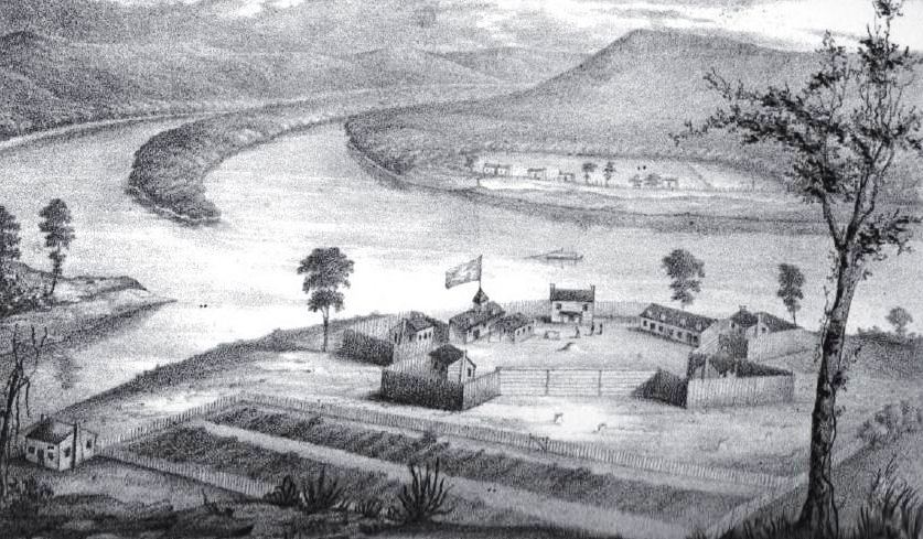
In the winter of 1788, Governor Arthur St. Clair attempted to negotiate yet another treaty at Fort Harmar, at the confluence of the Muskingum River with the Kaanseenseepiiwi (Ohio River). This site is near today’s Marietta, Ohio (see image below). Leaders from the Myaamia villages and from their allies among the Shawnee and Delaware refused to attend. St. Clair and Secretary of War Henry Knox eventually used their failure to attend as a part of the justification for attacking their villages on the Taawaawa Siipiiwi.[6]
Throughout 1789 and early 1790, the Myaamia and their allies living along the Maumee continued to refuse to negotiate a new border and the raiding war endured as both sides attacked each others’ villages. By May of 1790, the Americans decided that a larger military campaign was necessary. The Secretary of War, Henry Knox, wrote to Governor Arthur St. Clair and Brigadier-General Josiah Harmar declaring that the American public’s unease had made it necessary that the Army and Militia exterminate the peoples living in the Myaamia, Shawnee, and Delaware Villages living near the Taawaawa Siipiiwi.[7] Preparations for the invasion began shortly after.
On September 14, 1790, Knox gave his final instructions to Governor St. Clair and General Harmar. The Secretary of War stated that the purpose of the attack was to demonstrate “our power to punish” the Taawaawa Siipiiwi villages “for their depredations, for their conniving depredations with others, and for refusing to treat with the United States when invited.” Knox added that specifically “This power will be demonstrated by a sudden stroke, by which their towns and crops may be destroyed.” If possible, Harmar was also to build a fort along the Taawaawa Siipiiwi. He believed the presence of a fort would stop the Myaamia, Shawnee, and Delaware from rebuilding and would allow the United States a base from which to force the British out of Detroit.
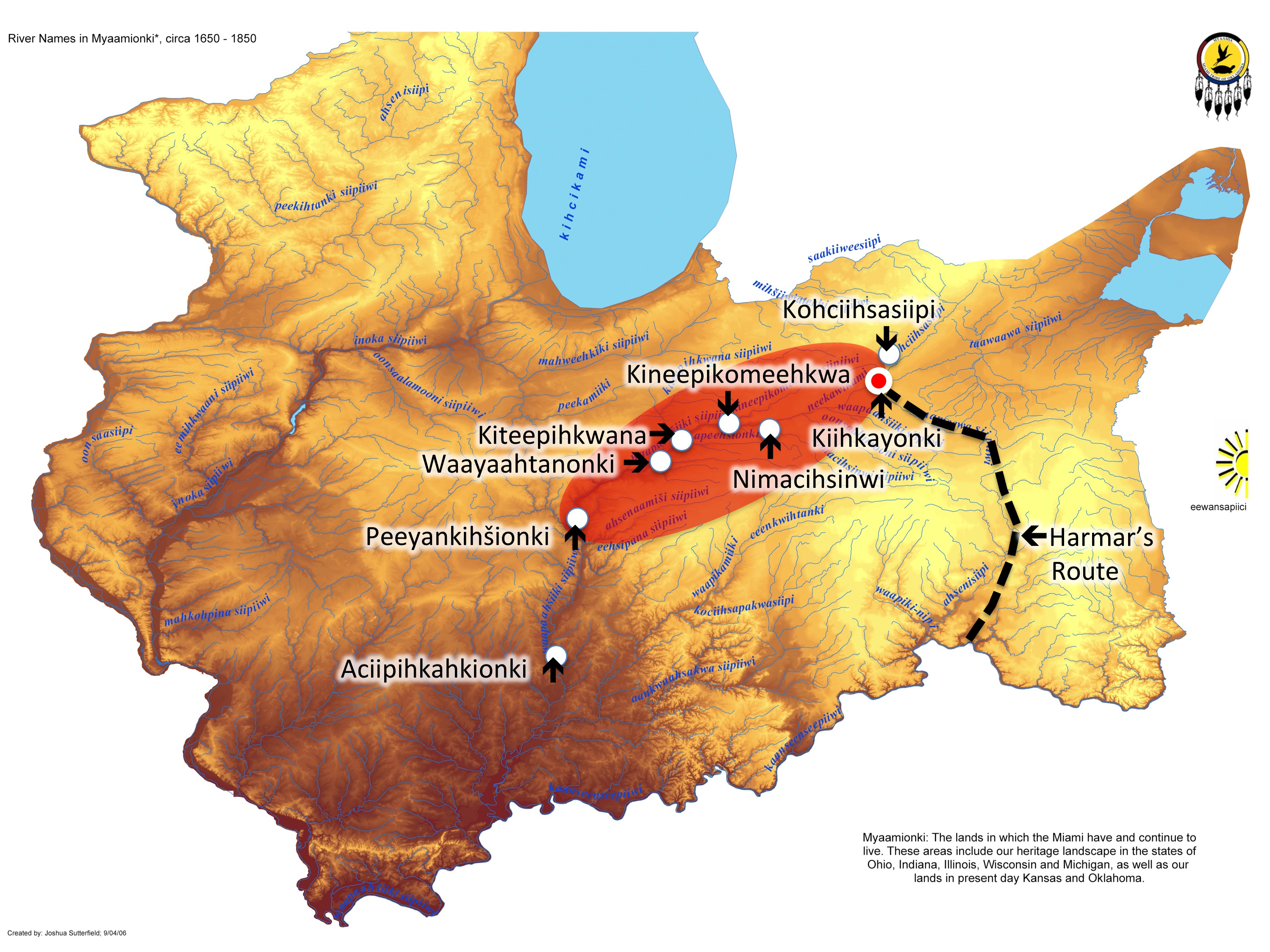
On September 26, Harmar’s invading army left Fort Washington (Cincinnati, Ohio). Under his command were 1,133 militia and 320 U.S. regulars. Their route followed the Little Miami River and then the Ahsenisiipi (Great Miami River) to the north. Their final advance was made while following the eastern bank of the Nameewa Siipiiwi (St. Marys River) to the northeast.[8] This route was the same trail that Myaamia men used for generations as a war trail to attack Cherokee villages south of the Kaanseenseepiiwi (See the map below).[9]
The people of the Taawaawa Siipiiwi villages remained unaware of the invading army until Harmar’s forces were about 35 miles south of their homes. Around October 13, the villages quickly decided that evacuation was the only way to ensure the safety of their families. In the Myaamia villages, there was enough time for both the men’s and women’s councils to meet. We cannot be absolutely sure these groups met, but it is likely that the decision to evacuate was made with both groups’ input. This is an important issue to remember. The movement of noncombatants, and whatever they could carry with them, was the responsibility of the women of the village. The women’s council also had an influence over decision regarding war and peace. As a result, we cannot forget that the hurried decisions made that fall likely included the voices, ideas, and will of the women of these villages.[10]
At Kiihkayonki, the Myaamia decided to burn their homes rather than leave them for the Mihši-maalhsa to pillage. Most of the Myaamia villagers relocated to the Myaamia and Potawatomi villages on the Mihšiiwiateehi Siipiiwi (Elkhart River) with some moving to the Kineepikwameekwa Siipiiwi (Eel River).[11] These evacuations continued through October 14. It was then the responsibility of the women of those villages, both Potawatomi and Myaamia, to find shelter, food, and clothing for their relatives who had suddenly become homeless refugees. This sacrifice is rarely noticed or commented upon, but it was vitally important to the survival of these refugee communities. The women of the Mihšiiwiateehi Siipiiwi (Elkhart River) and Kineepikwameekwa Siipiiwi (Eel River) villages likely shared their fall harvest with their relatives. They did so knowing that as a result their own community might not have enough for the coming winter.
Myaamia men of military age remained in the vicinity of the Taawaawa Siipiiwi, to await an opportunity to attack the American forces. The Delaware relocated their communities to the Waapikamiiki (White River) and the Shawnee moved theirs to the Auglaize, near it’s confluence with the Taawaawa Siipiiwi. Like the Myaamia, Shawnee and Delaware men also remained in the area awaiting the Mihši-maalhsa.[12]
The men of these villages were therefore watching closely as the Mihši-maalhsa arrived at the Taawaawa Siipiiwi on October 15. The first group to arrive was a force of around 600 mounted militia under the command of Colonel John Hardin and 50 U.S. Army regulars. The militia quickly demonstrated a lack order as men scattered throughout one village and then the next to loot what remained of the Myaamia homes, as well as the intact Shawnee and Delaware lodges. They went so far as to dig up hidden food supplies in their search for treasure.[13] The men from the villages were not ready to take advantage of this disorder, but they would remember the Mihši-maalhsa’s fondness for looting.
On October 17, the remainder of Harmar’s troops arrived at Kiihkayonki. As on the 15th, the militia commanders lost control of their men as they scattered to steal food and goods from the abandoned homes along the Taawaawa Siipiiwi. During the second day of the occupation, the men of these villages continued only to observe. Over that night, they took advantage of the disorder and stole perhaps as many as 100 packhorses along with a few cavalry mounts.[14] The horses would play a key role in the ambush attacks planned over the next few days.
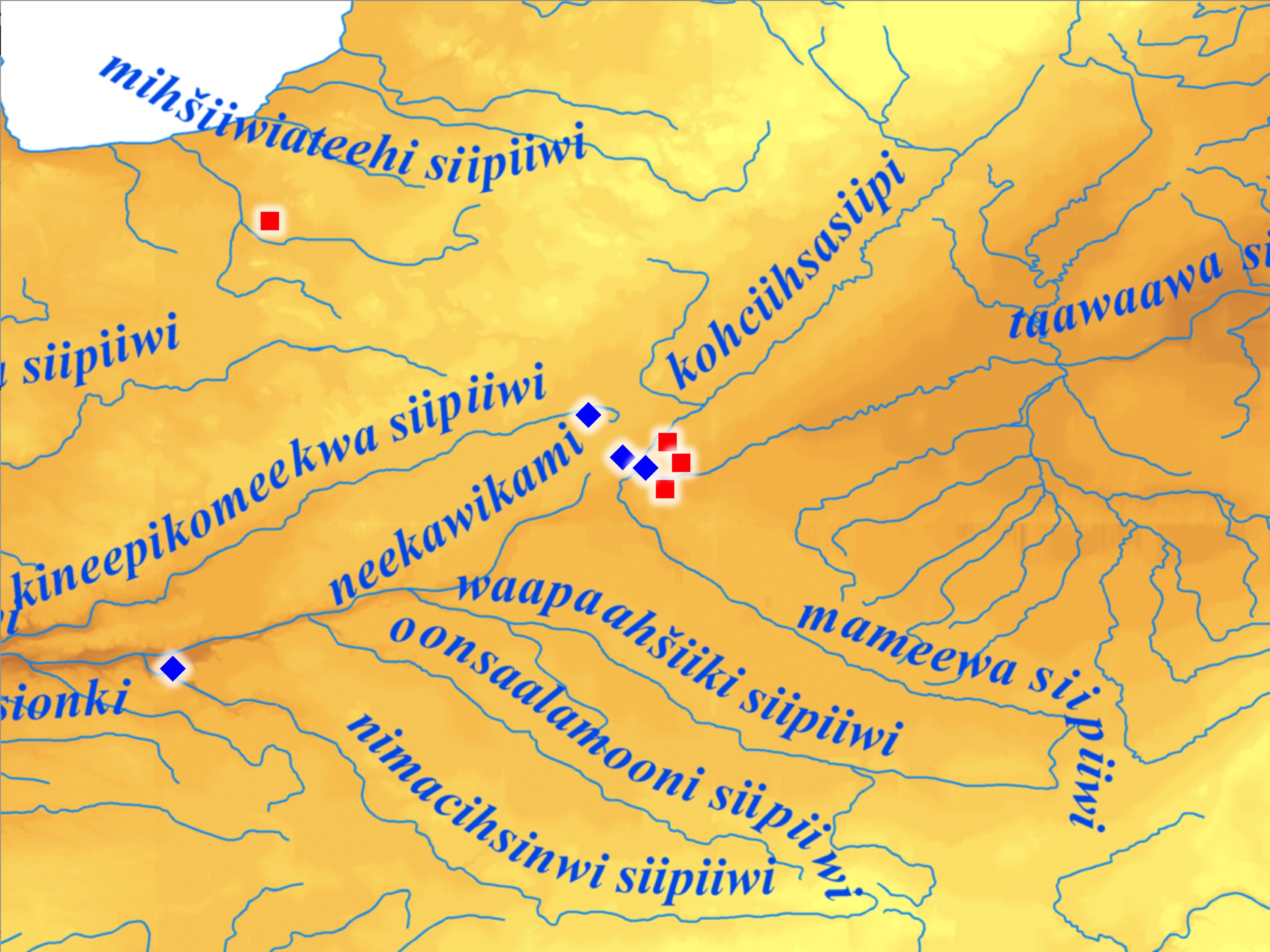
On the following morning, Myaamia men were well aware of the 300 militia who marched out of the American camp. Harmar had ordered Lieutenant Colonel James Trotter to take 300 militia and a few U.S. Army regulars to the northwest of Kiihkayonki to try and locate the noncombatants who had been evacuated and attempt to engage in a battle or skirmish with the men from the villages. The Myaamia men had limited numbers and this required them to guess which of the two trails the Mihši-maalhsa would choose. On this day, they set their ambush on the trail leading to Mihšiiwiateehi Siipiiwi, where most of the village’s noncombatants had fled (see map below). They also stationed scouts on the other main trail, which lay just to their southwest. This southern trail led to the Kineepikwameekwa headwaters village, which the Mihši-maalhsa had left alone up to this point.[15]
Around midmorning, two scouts on the Kineepikwameekwa trail were taken by surprise and killed by Trotter’s forces. Either there were other scouts, who escaped undetected, or the gunfire alerted the ambush party to the northeast. This group had at least 50 horses available and they quickly mounted and rode to assemble at a secondary ambush location on the Kineepikwameekwa trail. As they rushed to southwest, the group encountered a lone Mihši-maalhsa on horseback who appeared lost. He quickly turned and rode out of view. This lost militia soldier rode back to Trotter in a panic after his narrow escape and reported on the presence of the mounted men. In response, Trotter quickly withdrew and by evening his forces returned to Kiihkayonki.[16] If he had advanced, he likely would have stumbled into an ambush, which the mounted party was likely preparing up the trail.
On the night of October 18, the men of the Taawaawa Siipiiwi villages observed Harmar moving his base of operations to the Shawnee village of Chillicothe, which was to the east of Kiihkayonki. In the Mihši-maalhsa camp, the militia commanders argued fiercely about Trotter’s failure to locate either another village or to engage in at least a skirmish with the men of the Taawaawa Siipiiwi. One commander in particular, Colonel John Hardin, demanded to be allowed to restore the militia’s honor and return to the northwest trail and defeat the villagers in battle. Sometime during the night, Harmar relented to Hardin’s demands.
On October 19, scouts reported a slightly smaller force heading out of Chillicothe. This force consisted of 180 militia and 30 U.S. regulars and was commanded by Colonel Hardin. The scouts observed Hardin’s force move up the more northerly trail towards the Mihšiiwiateehi Siipiiwi in the direction of the Potawatomi-Myaamia village. As on the day before, the Taawaawa Siipiiwi men positioned scouts on the trail to serve as bait. On this occasion, the men were quick enough to escape. In the heat of the chase, the Mihši-maalhsa began to rush up a side trail. The pursuit strung out Hardin’s forces in a long line. Just south of the Kineepikwameekwa Siipiiwi the Mihši-maalhsa encountered a trail of trinkets that made it appear as though men from the villages were retreating in disorder. The bait for this trap had been set to intentionally take advantage of the earlier disorder observed among the Mihši-maalhsa when they arrived in Kiihkayonki. Between 100 and 150 Taawaawa Siipiiwi men were hidden on both sides of the trail, with some on the north side of the Kineepikwameekwa Siipiiwi and some on the south side (see the map below). Mihšihkinaahkwa, the most influential Myaamia war leader of the area, probably set this trap, but Shawnee and Delaware war leaders might have also participated in the planning and execution. The Myaamia participants were the most interested in stopping Hardin, as their families were in the Mihšiiwiateehi Siipiiwi village, which was Hardin’s target.[17]
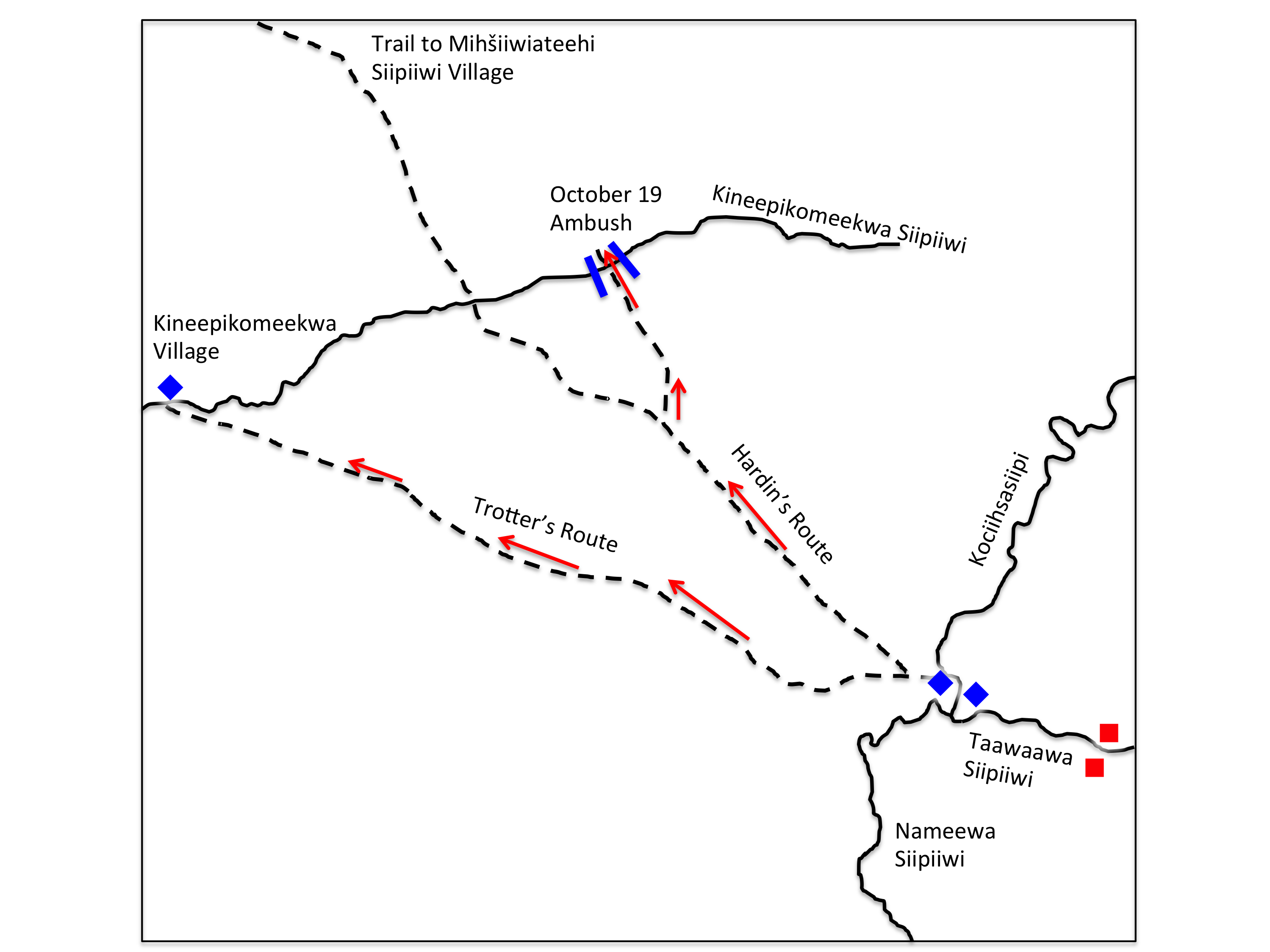
The trinkets produced the desired result. As the Mihši-maalhsa began to cross the Kineepikwameekwa Siipiiwi, the villagers opened fire. The men on the east side of the trail fired first, followed immediately by the men on the west. They then quickly charged the scattered Mihši-maalhsa and attacked hand-to-hand. The militia immediately turned and ran. They abandoned the 30 U.S. regulars who were attempting to form a line to fire. The regulars were then almost immediately overrun. The shell-shocked militia ran back along the trail. When they encountered the rest of the force, about a mile down the trail, they yelled at their comrades “For God’s sake retreat—you will be all killed—there is Indians enough to eat you all up.” Some of the Taawaawa Siipiiwi men moved down the trail following the retreating militia, but they stopped when they encountered this new group of about 75 men led by Major John Fontaine and Captain William Faulkner. This group was positioned securely behind trees and was well prepared to defend the trail. After some minutes of nervous waiting, Fontaine and Faulkner’s men decided to join the retreat.[18]
Hardin’s force returned piecemeal to the main camp at Chillicothe. Losses for this expedition were high. Twenty-two of the thirty regulars were killed in action, and 100 of 180 militia were missing in the immediate aftermath. Later in the night, 60 of the militia found their way back to camp. Over the next day, the realization sunk in that 40 militiamen were still missing and presumed dead. It is possible that some of the missing militia deserted and returned to Kentucky. In addition to the loss of life, Hardin’s forces left around 100 firearms behind in their disorderly retreat. Moral in the camp worsened as rumors spread that a “massacre” had occurred. Fear permeated the Mihši-maalhsa forces camping in the wreckage of Chillicothe, and friction between the U.S. Army regulars and the militia intensified.[19]
The next morning, Harmar ordered his troops to burn all the Taawaawa Siipiiwi villages and their food supplies. In total, Harmar’s army burned five villages and destroyed or consumed 20,000 bushels of corn as well as untold bushels of beans and squash.[20] As the day closed, Harmar’s forces began preparations for a return to Fort Washington. Harmar believed he had achieved his objectives by destroying the villages and their food supplies. This was an immensely damaging accomplishment. The lack of food would lead to untold suffering among the Taawaawa Siipiiwi villagers during the coming winter.
On October 21, the Mihši-maalhsa began their withdrawal from the Taawaawa Siipiiwi. Small contingents of Myaamia, Shawnee, and Delaware men trailed the withdrawing Mihši-maalhsa as they moved out a few hours after dawn. They carefully followed the army as it marched eight miles south along the Nameewa Siipiiwi (St. Marys River) and watched as they set up a camp for the night. They probably observed unusual behavior in the camp that night. The men and the horses did not quiet down as the night progressed, a general tension could probably be felt in the air. In the middle of the night, these scouts observed around 400 Mihši-maalhsa leave the camp and begin to move back towards the Taawaawa Siipiiwi. Some of men from the villages continued to shadow this returning force, while others raced back to the Taawaawa Siipiiwi to report that the soldiers were returning.[21]
Unbeknownst to the Myaamia, Shawnee, and Delaware, Colonel Hardin demanded that General Harmar allow him to return to the Taawaawa Siipiiwi and achieve a decisive victory. He also hoped to restore the honor of the militia after the rumors of their previous cowardice had spread throughout the army. After learning that villagers had begun to return to the Taawaawa Siipiiwi, General Harmar ordered 60 U.S. regulars and 340 militia to march overnight and attack the villagers as they returned to their homes. The entire force was under the command of Major John P. Wyllys of the U.S. Army.[22]
The Myaamia, Shawnee, and Delaware had around four hours to plan for the soldiers’ arrival. The men from the villages increased their numbers as Sauk, Meskwaki, Ottawa, and Potawatomi came from the north, west, and east to help with the defense of the Taawaawa Siipiiwi. Together, the war leaders from these communities planned a two-stage trap. First, a medium size group of about 20 to 30 men would hide above the ford across the Taawaawa Siipiiwi. They would fire down from thin cover on the Mihši-maalhsa after as they crossed the river. Once the troops crossed and began to advance up the riverbank, the ambushing party would flee attempting to bait the Mihši-maalhsa into recklessly chasing them through the burned remnants of the village cornfields. The chase would bring the Mihši-maalhsa between two larger groups who would create a deadly crossfire from the cover of nearby brush and trees. The goal was to force a disorganized retreat that could be attacked the entire eight miles back to Harmar’s camp.
The Mihši-maalhsa were unaware that they had lost the element of surprise. Instead of families returning home, they were to soon be facing prepared ambushes of men armed for war. Wyllys stopped his command about two miles south of the Taawaawa Siipiiwi in order to give final orders. He split his command three ways. First, he sent Major Horatio Hall with 150 Kentucky militia to the west and north to circle around Kiihkayonki and prepare an ambush north of the village. Major James McMillan and 150 Kentucky militia were ordered to circle to the east and north to sit parallel to Hall’s ambush. Wyllys would then cross the Taawaawa Siipiiwi with his regulars and 40 mounted militia led by Major John Fontaine. They would drive the returning villagers into Hall and McMillan’s ambush.[23]
Twenty to thirty men from the Taawaawa Siipiiwi villages were hiding in the thin brush at the top of the riverbank overlooking the ford as Wyllys and his U.S. regulars began crossing. They opened fire as the first ranks came out of the water. When Wyllys’s troops failed to quickly advance up the bank, the men continued to fire volley after volley into the crossing Mihši-maalhsa. Hearing the heavy fighting at the ford, McMillan abandoned his eastward movement and joined with Wyllys to push across the ford and up the riverbank. As planned, the Taawaawa Siipiiwi men ran and pulled the Mihši-maalhsa into the second trap.[24]
The Mihši-maalhsa pursued the men from the ford into the cornfield to the east of Myaamia village. McMillan’s men rushed ahead leaving Wyllys and the U.S. regulars isolated and on foot in the cornfield. At this moment, the second stage of the ambush erupted. First, between 50 and 75 men fired on the Wyllys’s troops from the west. As the soldiers turned to respond, a second group of around the same size fired from the east. The trap was a perfect crossfire. After a number of volleys, the men of the Taawaawa Siipiiwi attacked the Mihši-maalhsa in hand-to-hand combat in the cornfield. Within minutes Wyllys’s command was completely overrun and the survivors began to flee north following the direction taken by McMillan.
The Taawaawa Siipiiwi men pursued the Mihši-maalhsa closely until they rejoined McMillan who was returning south to check on Wyllys. A running battle ensued which moved gradually to the west and down the banks of the Kociihsasiipi (St. Josephs River). Here McMillan was joined by Hall’s troops, and a bloody and desperate fight developed in and around the river. The struggle continued until the men from the villages were able to break free and retreat.[25]
The remaining Mihši-maalhsa began a disorderly retreat from Kiihkayonki back across the Taawaawa Siipiiwi. The force was shadowed and attacked repeatedly on its eight-mile march back to the Mihši-maalhsa camp. The most reliable accounts of the battle claim that the villagers and their allies lost around 40 men. The Mihši-maalhsa faired much worse. Losses among the regulars were once again severe: 50 of the 60 men under Wyllys’s command were killed, including Wyllys. The militia reported 68 missing and presumed killed along with 27 wounded.[26]
The next day, the Mihši-maalhsa resumed their return march to Fort Washington. After the first night, the Taawaawa Siipiiwi villagers were unable to follow any further. Some historians have claimed that a lunar eclipse caused a superstitious reaction that ended the pursuit.[27] It is more likely that after ten days of disruption and fighting the villagers needed to care for their relocated families, begin to deal with the loss of food, and of course care for the dead and the families of the deceased.
Harmar’s army reached its destination on November 3. Upon his return, General Harmar admitted to Arthur St. Clair that “our loss is heavy.” John Cleves Symmes, a land speculator of considerable influence, used even stronger language. Symmes declared that the “repulse of our army” would drastically limit planned settlement north of the Kaanseenseepiiwi in coming year. He expected “that the panic running through this country will reach Jersey and deter many prospective settlers” from coming west.[28]
By January, some of the men from the Taawaawa Siipiiwi villages along with other allies, like the Wyandot, looked to take advantage of the weakened state of the Mihši-maalhsa. They organized attacks on settlements north of the Kaanseenseepiiwi at Dunlap’s Station (17 miles north of Fort Washington) and at Big Bottom (30 miles north of Fort Harmar).[29] However, these raids could not lesson the damage done by Harmar’s campaign.
Some American military leaders argued that destroying villages and burning crops was pointless. They argued that the villagers could “make themselves perfectly comfortable on meat alone, and can build houses with as much facility as a bird does his nest.”[30] This insulting statement implied that our ancestors and their homes were little better than those animals made and significantly misunderstood the importance of agriculture to our people’s lives. Nothing could be further from the truth. Preparing lodges appropriately for winter required the women of the village to dedicate hundreds of hours of labor. Much of the materials needed to make a lodge warm and dry for the winter, like cattail and bulrush, had to be located, harvested, processed, and woven into a final product. We must also remember the vast quantity of materials needed to replace all the homes that were lost in six villages.[31] Additionally, corn, and to a lessor extent beans and squash, formed a significant portion of the community diet. Without the fall harvest, many of the villagers were reduced to begging for corn from the British. The winter of 1790-91 was also extremely difficult for hunting as unusual blizzards decimated the bison populations on the Illinois prairies and made hunting deer and elk more challenging.[32]
The evidence of the suffering of the winter of 1790-91 serves as a reminder of the destructive outcomes of war. After a battle, or at the end of a war, some rush to identify “winners” and “losers.” But I’m reminded when I read the accounts of the Battle of Kiihkayonki that most conflicts are defined by loss. Each man, who died on the battlefield that October, was father, a brother, an uncle, or a son. Each death left a hole behind in the family of the deceased, both Myaamia and American. For many families this emptiness would never be filled. Over the cold and hungry winter that followed, the women, children, elders, and men who died of hunger or exposure only magnified the losses sustained in battle. To add to this tragedy, our people also lost a part of our shared history in the rubble of our towns. Thirty years after the battle, Pinšiwa (J.B. Richardville) and Meehcikilita (Le Gros) still painfully recalled the loss of important historical objects. In the chaos of the evacuation on the first day of the battle, the community accidentally set fire to two boxes that held “a large number of belts and pipes.” These objects were used to remember and retell our more ancient history. Without these belts and pipes much of that history couldn’t be retold and was not passed on to the next generation.[33] Today, we still feel the absence of those ancient histories.
In this article, I’ve tried my best to share the history of the Battle of Kiihkayonki from a Myaamia point of view. It is a story that I did not enjoy researching or writing, yet it is a story that needs to be told. Some of our ancestors found honor on the field of battle that fall and made lifelong reputations as a result of their skill and bravery. It is important for us as a community to honor the memory of their bravery and remember the difficulty of their sacrifices. We also honor them by remembering that the vast majority of our ancestors would have preferred a peaceful life unmarred by war, starvation, and relocation. I believe the same could be said of many of their American contemporaries.
In part three of this series (linked here), we examine the Mihši-maalhsa attacks on the lower Waapaahšiki Siipiiwi that preceded St. Clair’s invasion of the upper valley. We then turn to examining the Battle of the Wabash (St. Clair’s Defeat) and its aftermath from a Myaamia point of view.
If you would like to comment on this story, ask historical questions, or request a future post on a different topic, then please post a comment below. This blog is a place for our community to gather together to read, learn, and discuss our history. Our history belongs to all of us and I hope we can use this blog as one place to further our knowledge and or strengthen connections to our shared past.
You can also email me at ironstgm@miamioh.edu, call me at 513-529-5648, or write me at
George Ironstrack
Myaamia Center
Miami University
200 Bonham House
Oxford, OH 45056
[1] Helen Hornbeck Tanner and Miklos Pinther, Atlas of Great Lakes Indian History (Civilization of the American Indian series; v. 174. 1st ed. Norman: Published for the Newberry Library by the University of Oklahoma Press, 1987), Map 17, 85. Sword appears to have accidentally flipped Kiihkayonki and Le Gris Town. Wiley Sword, President Washington’s Indian War: the Struggle for the Old Northwest, 1790-1795 (Norman: University of Oklahoma Press, 1985), 80. Carter has one of the best maps of the Kiihkayonki area in Harvey Lewis Carter, The Life and Times of Little Turtle: First Sagamore of the Wabash (Urbana: University of Illinois Press, 1987), Map 4.
[2] The text of the Northwest Ordinance can be found at http://www.ourdocuments.gov/doc.php?flash=true&doc=8 . For more on the American political and economic context of the Ordinance see Sword, Washington’s Indian War, 47-48. The U.S. was publishing and distributing maps derived from the Ordinance that plotted as many as 10 states in the NW Territory. It is possible that this information found its way to the Taawaawa Siipiiwi villages via Detroit and the British or through other means. Neewe to Cameron Shriver for pointing out the quote in Putnam’s papers that describes these early maps. Rowina Buell, ed. “The Memoirs of Rufus Putnam and Certain Official Papers and Correspondence,” (Boston & New York: Houghton, Mifflin and Company Riverside Press, 1903), accessed online at https://play.google.com/books/reader?printsec=frontcover&output=reader&id=uZY0AAAAIAAJ&pg=GBS.PP1
146, 148, 181-83.

Leave a comment